
The Complicated History of a Very Simple Hall
An archaeological analysis of
The Hall at Le Boquet
Pont-Farcy
Normandy, France

 A study of a stone-built Hall at the centre of a group of houses and agricultural buildings built between the early 16th century and mid-19th century in the Bocage Virois in Normandy.
The hamlet of Le Boquet remains remarkably untouched by 19th/20th/21st century agricultural 'improvements'. At the centre is a Hall which, looked at from the west, appears to be nothing more than an early, well-proportioned, austere farm building with an agricultural doorway and no windows – perhaps a 16th century barn.
Looked at from the east it is more convincingly a habitation with two windows set into a multi-phase east wall, two hayloft entrances and a waste water exit for an internal sink. To the left is an over-sized doorway.
Looked at from the north, the gable end wall still looks agricultural, apart from two light embrasures set high on either side of the flue.
The surprise comes when you look inside. There, dominating the space, is a huge flag-stoned hearth under a massive oak mantle supported by two pairs of oak corbels.

It may have started life as an agricultural building before the 15th century and, by the late 18th century, it had certainly become so again. But, for perhaps 300 years, from the late 15th century to the late C18th, it was occupied as a 'hall', acquiring a staircase and gallery that led to an upper chamber in the early 16th century, occupied by some of the humblest sieurs in the Bocage Virois, but 'sires' of their little fiefdom all the same.
 Around the beginning of the 19th century it was re-developed as a granary, alongside cider production. In the 20th century it helped to provide a subsistance livelihood for its owners until, in the early years of the 21st century it was again inhabited — by us.
by Christopher Long

Le Boquet Analysis Images 2026
LE BOQUET HALL | PHASING
C15th or earlier | Late C15th | Early C16th | Late C17th | Late C18th-early C19th | 19th Century | 20th Century | 21st Century
LE BOQUET HOUSE | NOTES | CONCLUSIONS | ANCILLARY BUILDINGS | LE BOQUET VILLAGE


A floor plan produced by Robert Waterhouse during his week-long study of the Hall at Le Boquet.
PHASING
- PERHAPS A 14th TO 15th CENTURY TIMBER FRAMED PREDECESSOR? Mediaeval or Late Mediaeval
 It's quite likely that a simple timber-framed structure once stood here, typical of buildings in north-west Europe until the 15th century to 16th century. If so, its hearth may be the one we see today, misaligned with today's gable wall but perfectly aligned and square with a surviving line of deep-set wall footings which might have belonged to a timber structure. That said, any primitive timber predecessor could have been built for purely agricultural purposes, while any timber-built house of this period would probably have had a centrally situated fireplace beneath an open roof in order to minimise fire risk. No evidence of such a fireplace has not yet been found.

* Few such buildings survive in Manche or Calvados. Many thousands of them were replaced by stone-built structures in the 15th century and 16th century – a period sometimes known as the 'great reconstruction'. The Romans built almost exclusively in stone or brick. After them, for about 500 years, the descendants of Germanic peoples (e.g. Saxons and Franks) settled throughout north-western Europe, building almost exclusively in timber. And until quite recently, in the Pays d'Auge (eastern Normandy), houses continued to built like this in timber. Although Scandinavian 'norsemen', known to us as the Normans, preferred to build their churches and defensive structures in stone, nevertheless tens of thousands of mediaeval timber-framed houses survive in southern England and northern France. But in lower Normandy, perhaps because of the devastation caused by the Hundred Years' War and the Wars of Religion, the population overwhelmingly chose to rebuild their houses in stone – the massif armoricain being especially rich in granite, schist and sandstone. Beneath almost every 16th century or 17th century century house in Normandy, you might reasonably expect to find archaeological traces of a timber-built predecessor.
 When the renowned architectural historian Robert Waterhouse conducted his week-long analysis of Le Boquet in 2017, he strongly believed there had once been a timber frame facade along the eastern side of the house. He described how he was able to pass his hand through a clear gap between the eastern lateral wall and the re-built chimney gable wall and found a large space that he concluded was once occupied by a timber post.
Subsequent masonry, he thought, had been placed around this post which, when it rotted away, left a sort of photographic negative. Since there is every likelihood that there was indeed a timber-framed building here in the mediaeval or even late-mediaeval period, it is not unlikely that an eastern facade, with a window and a door, might have survived into, say, the 16th century (see conclusions below).
 In 2018, when removing a 20cm-40cm depth of clay from the floor – in the northern half of the building only – there was no evidence of previous occupation layers, nor of any floor paving. It was the same as the clay-rich orange-brown sub-soil (fine particles almost like loess) found in the surrounding land which we know to be at least four metres deep and probably much more, given that the nearby well is 15 metres deep before reaching bedrock.
 The surviving hearth was never situated in the centre of the Hall, nor in a lateral wall. It must date therefore from a later mediaeval period (14th-16th centuries).
In 2010 the hearth was found to be flush with the floor and paved with large stones (perhaps basalt), no doubt reused from La Pavée, a nearby Gallo-Roman road. They had the well-rounded edges of stones that had seen many centuries of wear.
A couple of flag stones like those in the hearth had been used as chocks for one of four 1,400 litre cider barrels, still in situ in 2010.
 There were also about 10-15 sharp-edged schist slabs (quite unlike the rounded Roman slabs) which at first glance looked as though they might once have been flooring but whose positions corresponded with the ends of several two-tonne barrels we found there which needed sturdy supports to keep their oak staves off damp ground. Nevertheless, these slabs may once been flooring. Almost identical slabs still pave the adjacent 19th century pigsty.

 However, there was also plenty of evidence of a lime-rich crust to the surface of what had clearly been a beaten earth floor. There was no evidence of a central hearth and no sherds or finds below the superficial first five centimetres. Those sherds found in the crust of the beaten earth floor (and outside the western doorway) have been conserved.
 There was clear evidence of a rudimentary underfloor drainage system running in two diagonal spurs from east to west across the northern half of the Hall, converging near the doorway and exiting beneath the northern end of today’s threshold on the western side of the building. There is surviving evidence too of three similar drains beneath the granary floor (in the southern half of the Hall) which run out under the low stone wall that now divides the Hall in two.
Surviving evidence: Perhaps the Hearth. Perhaps a length of Stone Footings beneath the inner skin of Northern Gable Wall forming perfect right-angle with hearth. Robert Waterhouse's 'gap in the stonework'. Otherwise none.
-
A LATE-15th CENTURY to EARLY-16th CENTURY THATCHED, STONE-BUILT DOMESTIC HALL WITH A HEARTH CENTRALLY POSITIONED IN ITS GABLE WALL. Late Mediaeval
By local standards of the 16th century, this is fairly large, well-proportioned building. Its walls cover a footprint of about 81 sq.m. but the whole layout differs from any typical local vernacular style. From what surviving evidence, it follows the classic maison-grange-étable formula only as far as the maison is concerned! The grange we see today is almost certainly of later date and nothing indicates there was ever an étable. (Only in the 19th century were a cowshed and pigsty added to the north of the building.)
At this stage the hearth was exactly centred in an original stone chimney gable wall, internally 5.78 metres wide. In 2010 it lay flush with the floor and below the outside ground level on the eastern side. It was closer to ground level on the western side. The system of drains (see above) provides some indication of levels.

 The inner skin of the chimney gable wall was entirely replaced and extended in the mid-1500s so only the external face of the gable wall dates from this phase. Its upper parts can be seen from outside but most of it is visible from within the adjacent 19th century cowshed and pigsty and their hayloft above. In the pigsty it can clearly be seen that the original wall terminates and an extension has been added.
 The corbels, mantle and hood over the hearth projected further into the room than they do today, exactly covering the hearth below. It seems that in the next phase (see below) they were reduced in depth by about 30cm, as can be seen from the misaligned chamfer stops, visible under the hood –
A line of surviving wall footings to the east of the hearth indicates this original gable wall was in this phase aligned slightly differently, forming a perfect right-angle with the hearth, which its replacement (see below) does not.
The building was probably three bays long (3 x 3 metres) if the two surviving roof truss frames are from this period. Its length therefore was probably much as it is today. There is no evidence of any living space other than the ground floor although it is unlikely that the entire surface would have been used for domestic purposes. Perhaps half might have served agricultural needs. Nor is there any evidence of the position of doors or windows other than those we see today (all of which are believed to have been created later).
 Significantly, the chimney gable wall lacks (and presumably always lacked) the standard-issue Norman cupboard set into the wall beside the fireplace. Large recesses in the masonry for food storage, with wooden shelves and a cupboard door, were almost universal features of vernacular architecture in this region from at least the 16th century onwards. It was something that a mason would have integrated during construction and not something that could easily be retro-fitted.
 The lack of such a cupboard suggests that the original wall was not built deep enough to accommodate one, or even that it was not originally destined for domestic use – supporting the theory that an agricultural building was later transformed into a habitation with a hearth and chimney.
There is no evidence for the state of the eastern lateral wall or the southern gable wall in this phase. In any case we know that both were rebuilt at least once. But since the room must have had a window and there is no evidence of one on the western side we assume light arrived from the east where windows and doors would have been protected from the prevailing wind and rain.
We are reasonably sure that today's 'agricultural' doorway in the western lateral wall was introduced at a later date, so the original principal doorway was probably somewhere along the southern half of the eastern facade (as it is today) even though ground level on that side would imply two or three steps down into the room... All in all, we are forever baffled by the question of doors and windows in the eastern lateral wall!
 It's possible that the northern end of the western lateral wall dates from this period but it's more likely that it was even earlier since it has an agricultural-looking ventilation hole just below the roof-plate – unnecessary and a nuisance in a domestic building.
NB If it can be shown that the earliest surviving stonework in the building includes this stretch of wall, this might indicate that it first had an agricultural purpose before being converted into a house with a chimney and hearth.
Surviving evidence: The Hearth. The outer skin of the Northern Gable Wall. Perhaps a length of Stone Footings in the eastern end of the Northern Gable Wall. Probably the majority of the Western Lateral Wall including its Ventilation Hole.
-
AN EARLY-16th CENTURY THATCHED, STONE-BUILT DOMESTIC HALL WITH AN OFF-SET HEARTH IN A WIDENED GABLE WALL TO ACCOMMODATE A STAIRWAY TO A GALLERY AND UPPER CHAMBER. Rural Renaissance
This involved the demolition and rebuilding of the entire inner skin of the chimney gable wall to increase its internal length eastwards by 50cm (from 5.78 to 6.28 metres).
The extra width was needed for the creation of a stairway and gallery along the eastern lateral wall giving access to an upper chamber (sometimes known as a solar).
Inevitably the whole fireplace and chimney structure was now off-set to the left of the wall's new centre line.
 We can be reasonably certain of the line of the staircase. It rose about three steps high along the north-eastern gable wall before turning 90° along the north-eastern lateral wall and climbing about seven further steps. Fortunately a putt-hole survives to indicate where it was supported. At an angle of about 45° it neatly avoided blocking either window and arrived at a gallery about 210 cm above the Hall floor where it was no doubt supported by the two long horizontal timbers which survive embedded in the wall.
At Le Boquet we can therefore date this stairway-gallery-upper chamber (open to the roof-space) phase to some time during the late 15th or early 16th centuries and the existance of the putt-hole indicates that at least this small part of the wall was created at the same time. **
 ** This layout at Le Boquet exactly follows, in very simple form, the now well-known gallery-corridor formula, a rural renaissance architectural scheme frequently found in late-15th century to mid-16th century houses in Normandy's southern Manche.
The gallery-corridor layout was designed for a hall (i.e. the sole main living room) which, until the mid-16th century, was almost always open to the roof-space but where access was needed to upper chambers that were situated on one or perhaps both sides of the open hall.
The solution involved a staircase (either within the house or within a stair-tower) which rose to a gallery along a lateral wall overlooking the hall below (or perhaps partitioned off from it as at l'Erre). This gallery then gave access to the upper chambers at either end.
 The effect of the overhead gallery was to create a corresponding service corridor at ground floor level giving servants access to the hall from behind a screen as well as to kitchens and storerooms situated beneath the upper chambers.
The screen was often a curtain or tapestry hung from the gallery to the ground below, hiding the service area from the hall. In 16th century England a gallery wall hanging of this sort was often known as an Arras (the city of Arras in northern France being famed in England for its woven textiles).
Shakespeare is not alone in using the Arras as a device by which characters can over-hear the conversations of others, often leading to conspiracies or even assassinations when victims were stabbed from 'behind the Arras'.
There are scores of examples of this architectural scheme in southern Manche but the outstanding example is that of the Manoir de l'Erre at Champcervon (see picture above).
By around 1570-85 the fashion was to 'close' the hall by introducing a ground-floor ceiling (see l'Aumoire (Morigny), La Ricouvière and La Bouillère (Saint-Vigor). The former gallery then became a simple corridor on the first floor, still with access to upper chambers but also to the new room created over the former open hall.
It would certainly have been easier to heat a room that was no longer open to the roof, but the seigneurial class also seems to have acquired a need for discrete upper chambers and bedrooms, away from the more formal reception hall below and the distractions of domestic life where cooking still took place over the open fire. In this way Norman households were first introduced to the civilising influence of the north-Italian Renaissance. Anglo-Norman historians owe a great debt to David Nicolas-Méry who first identified and described the 'gallery-corridor' feature in the early 2000s, finding many examples of this vernacular style in south Manche.
The author was fortunate to take part in this quest and to discover further examples!
A simple first step in identifying houses of this sort is to observe that the fireplace and chimney are off-set to one side of the centre line of the hall by perhaps one metre of more.
A second step is to find evidence of a former corridor along the ground floor and a corresponding fromer gallery above.
Projecting corbles which once supported the gallery but are no longer serving a purpose are often useful indicators.
Yet another indicator is where surviving doorways at ground floor (corridor) or upper floor (gallery) levels are cearly in line with the ends of passageways that no longer exist. The position and height of the upper chamber can be seen from three surviving corbel holes in the southern end of the western lateral wall. One of these holes even contains its original corbel.
Although Le Boquet must always have held a very low position in the seigneurial scale of Norman society, for the owners of this humble Hall the creation of an upper chamber would have been a significant development and some mark of their local status.
 This upper chamber was thus accessed by a stairway which rose about 210cm to a gallery about 230cm long on the eastern lateral wall, overlooking the Hall below.
From here there one passed through a low doorway (only about 180cm high) which was constrained by the fixed height of the pre-existing southern roof frame truss. There would then have been a further three steps or so, about 50 cm, in order to reach the floor level of the upper chamber.
 Inevitably the truss beam became the doorway's lintel, on the underside of which are two surviving mortice holes which once contained the tenons of a pair of door posts. The lintel between them has been carefully chamfered to give the formerly crude roof frame a touch of elegance (around the doorway at least...).

 A line of holes along the top of the southern truss beam show that the gallery was closed off from the Hall below. The holes received the vertical stud-work of a wattle-and-daub partition that reached the ceiling at the level indicated by two decorated corbels on either side of the chimney flue (set at slightly different heights). Almost certainly this partition was like the one that survives at the Manoir de l'Erre.

 The upper chamber presumably had its own ceiling but we do not know whether this corresponded to the pair of corbels in the chimney gable wall about 30 cm above the wall-plate level, or perhaps the corbel holes higher up in the same wall, just above the light embrasures.
 The southern truss frame may at this stage have been moved northwards to increase the bedroom space to almost half the length of the Hall. If so, this may explain why the northern truss frame was also moved north – so far north in fact that it now serves little purpose at all. The purlins do not really need it since they can be seated directly into the adjacent chimney gable wall.***

 The northern truss frame seems to be of a similar age and style to the southern truss frame, though with fewer chamfers and less refinement, probably because it was not part of the upper chamber structure. They both use the 'peg-lock' system for holding an angled tenon on the king-post into an angled mortice in the truss.

 But strangely while the beam of the northern truss frame still manages to sit on the wall-plates at each end, the eastern end of the southern truss beam has to be supported by a post sitting on a ledge because the eastern wall at this point is not sufficiently thick. We know this part of the wall was built later (see below) but the failure to make the wall thick enough is strange...

*** The Hall probably had three equally spaced bays with roof truss frames distributed in the conventional manner until the upper chamber was created. At this point, as we've seen, both were moved northwards. The southern frame may even have been moved still further north when granary was developed at the turn of the 19th century (see below). In 2022 CAL moved the southern truss frame southwards again by about 30cm in order to align it better with the two beams below it. At the same time a new Douglas frame was placed on the southern gable wall to replace a rotten half-frame that must have dated from the 19th century construction of the southern gable wall.
Returning to the ground floor and the new internal skin of the chimney gable wall, this now consisted of high quality masonry around the original hearth and incorporated today's chimney breast including its stone niches, timber corbels, timber mantle, clay-rendered stone hood (probably whitewashed), stone chimney flue and four ceiling corbel holes (above and below the light embrasures) two of which still contain their timber corbels.
It also allowed for the creation of the rather remarkable hidden cache – the arm-deep space within the thickness of the wall for hiding money or small valuables. Finally there were two ventilation light embrasures of differing conformation at the apex of the gable, presumably to light an attic space****.**** There is plenty of local evidence to show that attic spaces such as this were used to accommodate maids' quarters and/or dovecotes.)
Almost certainly it was now that the oak corbels and oak mantle were set back into the wall (see the 30 centimetre chamfer misalignment under the hood) so that they protrude less into the room. If they were set as originally intended they would be a precise fit for this particular hearth. Today the hearth is notably not entirely covered by the reduced mantle.
The rebuilding of the inner skin of the northern gable wall also explains why no attempt was made to link the internal stonework into the lateral walls. Presumably linking the external stonework was deemed sufficient and these quoins are visible outside where some have fractured – perhaps because the inner skin was not interlinked!
 The presence of the upper chamber corbel holes tells us the western lateral wall existed at this stage and the exterior of this wall can be distinguished from the northern end by the presence of a regular pattern of surviving putt-holes for scaffolding. Disturbance of this pattern suggests that the present 'agricultural' western doorway was a later creation (but see later discussion). We can also see that the southern gable wall was a later development – probably built at the turn of the 18th/19th centuries.
Significantly too, the inside of the southern end of the western lateral wall contains two lantern recesses which indicate they needed more than natural ambient light. This would have been the case if the upper chamber was now blocking the light. But this was probably not a service area as there is no evidence of a waste water spout from a sink through this wall.
Lantern recesses were usually set quite high in a wall: (a) to disperse light as widely as possible and (b) to reduce fire risk. These two niches are indeed set high if you exclude the subsequent raised height of the granary threshing floor (see below). Altogether the whole length of the western lateral wall may contain at least three distinct phases of masonry with much disturbance around the wester doorway.
 While the corbel holes in the western lateral wall give us a height and depth for the upper chamber we have no way of knowing what supported it above the floor of the Hall below. It may have sat on a transverse beam or even an arcade such as the one that supported Le Boquet's 19th century cart shed extension (see below).
And very importantly we do not know what the space below the upper chamber was used for. This would have been almost 50 per cent of the building's surface area. Was it agricultural or domestic – housing animals or humans? Was it a store for tools, grain, seed, ploughs, cider barrels or even the means of making cider itself? Was it in fact a granary, therefore conforming more closely to the classic maison-grange-étable model? If so there were very possibly two separate doorways in the southern half of the eastern lateral wall.
Among other considerations are these:
The upper chamber surely needed a window of its own but we have no evidence for one because the corresponding length of wall was later rebuilt.
The eastern lateral wall stonework around the taller of the two windows is almost certainly contemporary with the new chimney gable wall but, if so, why is it made of fragile, non-matching schist rather than sandstone?********** Did the very competent mason who built the fireplace wall in fact build another lateral wall with a window that has now disappeared? The larger of the two windows is correct for its time and positioned as one would expect, though it is missing the almost obligatory iron grill and its lintel appears to have been replaced. But the smaller window is an illogical size and perhaps only needed for the staircase. Would he have created the illogical smaller window? Was this window created by an amateur later on? How else should we read the very unsatisfactory situation in this corner of the building, visible from the outside? Missing stonework seems to have been filled with clay, alongside bodged repairs... Is today's eastern lateral wall a repair/replacement for something that collapsed?
 Another mystery involves the smaller window which looks like an afterthought, set in a severely misaligned length of poor masonry, with inadequate footings and bulging stonework that has been badly repaired. It may be that the timber staircase attached to it attracted damp and rot over a period of time and this damaged the wall, but its misalignment and poor construction remain puzzling.
We have no idea what the southern half of the eastern lateral wall consisted of at this stage, but it seems almost unthinkable that a south-eastern facade with windows, in this context and in this region would not have contained a main front door for domestic purposes!
Another mystery involves the smaller window which looks like an afterthought, set in a severely misaligned length of poor masonry, with inadequate footings and bulging stonework that has been badly repaired. It may be that the timber staircase attached to it attracted damp and rot over a period of time and this damaged the wall, but its misalignment and poor construction remain puzzling.
We have no idea what the southern half of the eastern lateral wall consisted of at this stage, but it seems almost unthinkable that a south-eastern facade with windows, in this context and in this region would not have contained a main front door for domestic purposes!
Nor do we anything about the southern gable wall at this time and how the southern end of the thatched roof would have been supported. Did it have a pointed gable to match the northern end or perhaps a hip roof of some sort designed to deal with prevailing south-westerly winds? Certainly the occupants of the fashionable upper chamber would have wanted to avoid the full, prevailing blast of Normandy's renowned westerly winds and rain.
Surviving evidence: Entire Northern Gable Wall (inner + outer skins). The Hearth. Entire Fireplace + Chimney arrangement. Ceiling Corbels in Northern Gable Wall at roof-plate height. Mortice holes for Gallery Doorposts and Chamfered Lintel detailing under the Southern Truss Beam. The entire Northern end of the Eastern Lateral Wall + 2 Windows. A Putt-hole and two Lateral Timbers supporting a Staircase and Gallery to an Upper Chamber. Stud-work holes for the Upper Chamber Partition on the top surface of the Southern Truss Beam. Upper Chamber Corbels in southern end of the Western Lateral Wall + Lantern Recesses in the wall beneath them. The entire Western Lateral Wall plus Putt-holes and Ventilation Hole.
-
A LATE 17th OR EARLY 18th CENTURY THATCHED, STONE-BUILT HALL, ABANDONED AS A HOUSE AND CONVERTED TO AGRICULTURAL USE. Early Modern France
The Hall now appears to have been abandoned for domestic purposes and to have become a purely agricultural building but we don't know why or when. In 2010 we were surprised to find no carbon deposits, nor any signs of soot in the fireplace or chimney flue. The author has no idea how long it might take for such evidence to disappear naturally but presumably this could take a couple of centuries or more.
The most likely reasons for abandoning a house would have included depopulation and economic decline caused by plague or war. The Wars of Religion (1562-1598) and the catastrophic famine of 1693-1694 are both potential causes. ************ The Wars of Religion resulted in a substantial population decline in Normandy. Population decline throughout France is estimated at 2 million to 4 million as a direct consequence of violence, famine, and disease. The disruption to local economies and communities contributed to further population loss.
It's particularly significant that Le Boquet's owners did not not follow the prevailing fashion of 'closing' the Hall to create a ground floor room with a ceiling. The transformation of open halls to closed halls (as described above) seems to have occurred in the second half of the 16th century and was probably almost universal by the 1580s (see: La Bouillère, La Ricouvière, L'Aumoire, etc). This period coincided with the Wars of Religion when this part of Normandy had a large population of protestants. If Le Boquet's owners did not close their Hall like most others, was this because they had already abandoned it?
The 17th century in Normandy also saw severe economic depression driven by inflation and heavy taxation during Louis XIV's wars. One result was the catastrophic famine of 1693–1694 when a sudden cold period combined with poor harvests led to food shortages, starvation and high mortality in Normandy, killing an estimated 1.3 to 2 million people nationwide and causing widespread social unrest.
And it may be significant that Le Boquet House (fifty metres to the south, and perhaps of the same era as the Hall) once had a hall room open to the roof, did not then have an upper chamber but was later 'closed' to create a ceilinged living room with a hayloft above. It's very possible that the two houses were owned by the same family but it seems as though those involved might have faced a severe economic downturn – perhaps in the late-17th to early C18th. Alteratively, bearing in mind that there was a signicant development of housing in the town of Pont-Farcy in this period, it could be that the families moved away from the land and farmed it from a distance, perhaps leaving a manager to occupy Le Boquet House. Whatever the reasons and timing, the Hall was once again transformed, this time by the introduction of two massive, un-chamfered oak transverse beams, only just above head height, fitted with oak floor joists. These created three bays of unequal size for an agricultural space below and haylofts above. For want of more informations we could just call this a barn.
The joists are rough-and-ready, as are the beams, with none of the chamfering expected in a domestic setting. Nevertheless, it is unusual to see an oak-joist ceiling with a 15 centimetre clay floor above in a purely agricultural setting, especially if the space above were to be no more than a hayloft.************** The usual agricultural method was to lay substantial ash or hazel poles across the beams which were themselves cross-covered with thick branches. The author remembers these well. They were dangerous to walk over until there was sufficient depth of hay (preferably hay-bales) but the structure could safely support a vast weight of hay or straw up to the roof-top.
 NB. We believe the whole ground floor surface was involved because the ends of three pegged joists from the array of joists in the southern bay have survived. If our reading of these peg-ended joists is wrong, then it is feasible that the southern half of the barn was not similar to the two bays in the northern half and might have had another specific use.
Inevitably the stairway and gallery disappeared at this stage and perhaps the granite sink and the rest of the service area under the former gallery were also lost. And there is no evidence of any internal access to the first floor in the northern and central bays though there might have been steps or a fixed ladder in the southern bay.
 The most likely access points into the newly created first floor space would have been through one or more hayloft doorways via a ladder from the outside. If so, it is very obvious that the masonry around today's northern hayloft doorway is not homogenous. The northern side of the doorway has been simply broken through leaving a ragged edge. On the southern side of the doorway the masonry is neatly finished – presumably because it was constructed later. This is useful to us because it indicates that the surrounding wall to the north pre-dates the introduction of the beams which created the hayloft while the masonry to the south must be subsequent to both. The southern hayloft (set much higher) was created much later when the granary development occurred (see below).
 The way in which the transverse beams were introduced into the pre-existing western lateral wall is very visible from the 'broken' internal masonry.
Clearly the northern beam was seated into the pre-existing northern length of the eastern lateral wall, above its window, without having to break through the full thickness of the wall (see above).
 But were these beams associated with the creation of the western doorway which is also agricultural rather than domestic in both form and height? The first evidence we have for the existence of this western doorway is that one of the beams sits uncomfortably on top of the end of the doorway's crude and deformed lintel and that such a doorway could only have served agricultural needs. The doorway is equipped with massive timber 'bar' cheeks set deep into the door jams on either side – typical of vernacular architecture in the Bocage Virois. But the hole into which the bar would slide looks relatively insubstantial and would only work in an agricultural context if you could bar this door from the inside and then leave the building by another lockable doorway.
 The ceiling created by these two beams survives largely intact. In 2018 we dismantled a few metres of it inside the western door because damp had penetrated the clay and rotted many of the ribs, creating holes that we hope to repair using the original technique. The ribs are short lengths of split chestnut (about 30cm long) tightly rolled in about 5 centimetres of straw, dipped into clay mud from sub-soil outside.

 These were then laid side by side across the joists, gluing themselves to each other as they dried and providing a solid base on which to apply about 15-20 centimetres of damp clay which dried to form a durable and resistant floor above the joists. This was the standard method of making an upper floor in this region, from mediaeval times through to the 19th century, but the overwhelming majority of such ceilings had been lost by the early 21st century.********
******** In grander houses, inhabited upper floors with a clay floor like this were often topped by a layer of small square or hexagonal tiles (tomettes), sometimes coloured with deep green or ochre glazes (see images from the Manoir du Guescelin at Longueville).
It’s still unclear what the southern half of the eastern lateral wall consisted of at this stage, so we have no proof that there had ever been a main domestic door into the Hall on the eastern facade – though such a door would now be serving a barn.
 Indeed, if there existed a sheltered eastern doorway, would the formerly domestic Hall ever have needed a western doorway, full face to the westerly wind and rain?
Perhaps... because curiously, the Le Boquet 'House', 50 metres south, shows clear evidence of having had an almost identically positioned low western doorway that reached ground surface level (see photos right). Were doors like this necessary at some stage, perhaps because an agricultural task required the use of domestic living space? In a barn, however, the western doorway makes sense. It was once considerably wider than it is today – large enough for farm carts of the period or for cider production, including ‘700 pots’ (1,400 litre) cider barrels.
Its width has been altered at least once. Indeed the masonry around this doorway and its awkward lintel show radical alterations have occurred. The present threshold stone looks like an improvised import and would have impeded cartwheels. It even impedes human access at the door's present height and we have no evidence for when it was introduced or what preceded it. And since it is unlikely that anyone was expected to live in the Hall at this 'barn' stage, a threshold might not have become necessary until much later.We should remember that in 2010 the chimney flue was entirely free of soot with no evidence there had ever been a fire in it which suggests the Hall was long ago abandoned as a house. And it's unlikely that anyone moved from Le Boquet Hall into the Le Boquet House (75 metres south west of the Hall) because the House was almost certainly of the same date, with similar characteristics to those of the Hall but without the benefit even of an upper chamber.
Surviving evidence: Two Transverse Beams. Floor Joists in the northern and central bays with Peg-end Joists protruding into the central bay from the southern bay. The wide Doorway in the Western Lateral Wall. A lack of any Soot in the Chimney Flue.
It is still less likely that anyone would have moved from the Hall to Le Boquet Cottage (50 metres to the west of the Hall) which was surely built in the 18th or 19th centuries and which offered very few comforts indeed.
We don't know the extent of the land owned by the owners of Le Boquet fief which may or may not have included both the House and the Hall. The simplest explanation is quite simply a drastic rural depopulation and that suggests some time between the late 16th century and the late 17th century. Alternatively, as we saw above, they may have preferred the comforts of living in a new town house in Pont-Farcy and simply abandoned the Hall to become a barn and the House to become a house for an employee.
-
A LATE-18th OR EARLY-19th CENTURY THATCHED, STONE BUILT HALL, PARTIALLY REBUILT AS A GRANARY AND FOR CIDER PRODUCTION NAPOLEONIC ERA
 At this stage almost the all the southern half of the Hall was transformed into a granary involving a considerable investment in masonry and carpentry. It suggests a period of agricultural prosperity – perhaps the result of freedoms gained by the 1789 French Revolution.
 The project involved entirely rebuilding the southern half of the eastern lateral wall and the entire southern gable wall (topped with a small timber frame to create a hipped roof). It also involved the building of a dedicated pressoir on the southern gable wall. These involved good quality masonry done in sandstone. Within these walls a raised threshing floor was built under a high ceiling, with a hay or straw loft above.
 The ceiling survives, well constructed in good quality timber, seated on a new beam that was introduced between the southern truss beam in the roof space and the southern transverse beam below it at ground floor level.
The granary was also equipped with the tall eastern door we see today which allowed sheaves of wheat or barley to be pitch-forked onto the threshing floor where men, wielding flails, separated the grain from the straw and chaff at harvest time.
Of course this doorway may be an adaption of a pre-existing doorway, evidence for which might one day be found beneath the threshing floor. It seems very probable that earlier phases of the Hall had a doorway somewhere in the southern part of the eastern wall.A standard feature of almost all farms in this region from at least the 16th century through to the 19th century was the raised granary grange with a tall doorway positioned adjacent to the farm's sole living space la maison (often with an internal communicating door). While threshing occurred at harvest time in July/August, the granary also served as the business centre of the farm throughout the year, acting as an office, a storeroom for valuable tools and a dry space for stocking grain, seed etc. One can imagine the master organising work and deploying labourers from here.


 The threshing floor was set 60 centimetres above the ground on a bed of large, loosely packed stones to prevent the rise of humidity. Onto this was laid a layer of beaten earth (terre-battue restored by us in 2019). The floor is surely unnessesarily wide for the modest harvests that Le Boquet could have produced, but the size was probably dictated by the position of the southern truss beam. And it could be that the granary was used cooperatively by neighbours.
 The raised floor was retained by a low stone wall across the full width of the building, topped by a chamfered timber sole plate. Three drainage holes passed under the retaining wall and once joined the east-west drain that crossed the northern half of the Hall and flowed beneath the threshold of the western lateral door.
 Today the sole plate beside the threshing floor supports a partition of light-weight planks of inferior quality, along with a poorly made communicating door. The partition is amateurishly attached to the underside of the southern beam by flimsy laths.
The building is thus divided in two on the ground floor. But when did this occur? The investment in the granary would surely have foreseen use of the whole building for agriculture, so that, for example, small carts of the period might have been driven into the former living space to be loaded and unloaded from the raised threshing floor. And this in turn suggests a reason for the widening of the western door.
The other possibility is that the partition was designed to exclude light from an area now full of barrels of cider and to prevent the dank humidity from the barrels affecting the cereal products. A wide doorway is certainly needed when barrels are taken out for cleaning or replacement.
And surely even a labourer was not expected to live in one half of a barn, with a fireplace that shows no sign of having been used for a century or two, especially if he were exposed to the prevailing wind through a wide agricultural doorway?
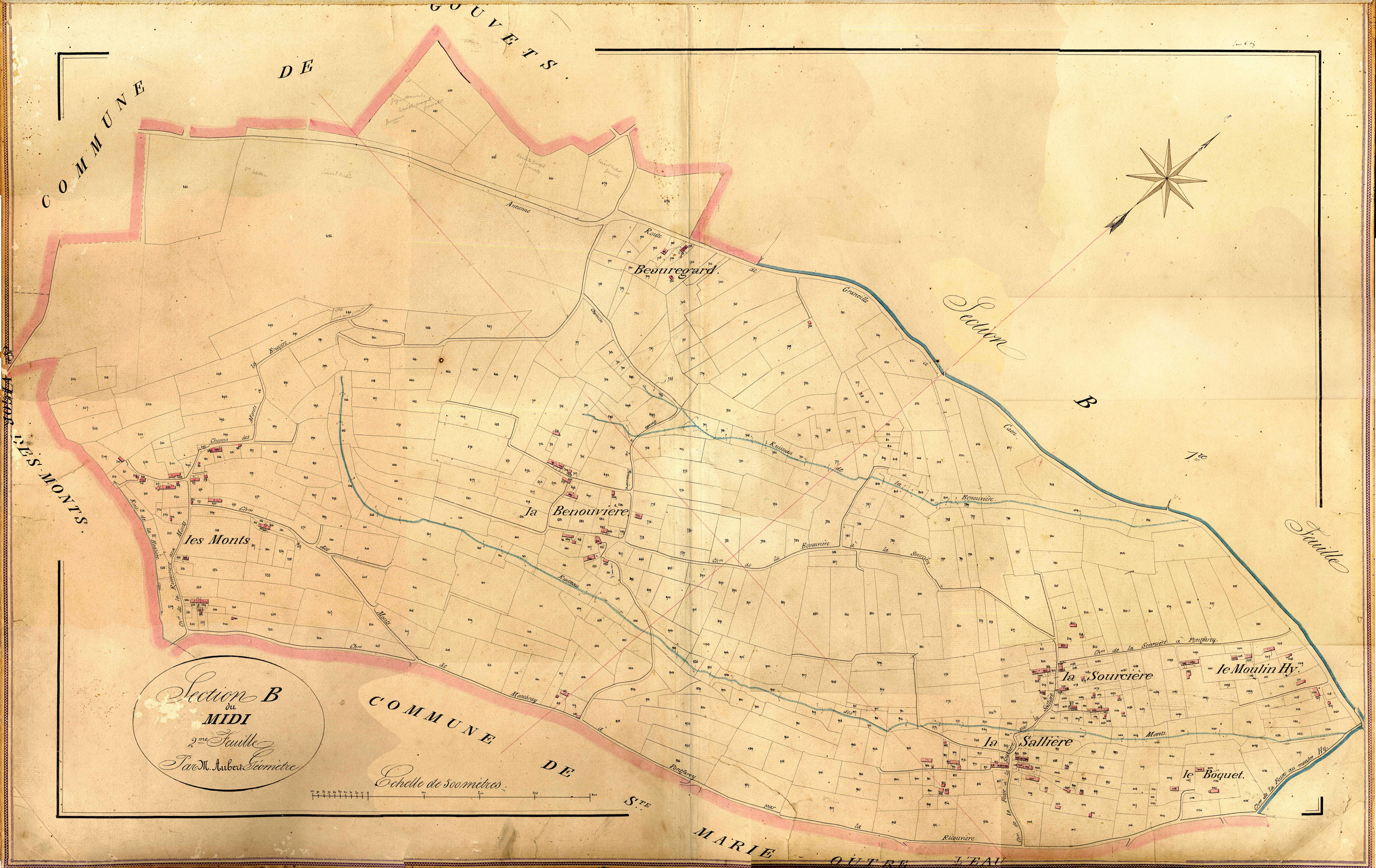
 Significantly, the granary development also seems to have involved the construction another building that had almost entirely disappeared by 2010. This was an extension beyond the southern gable wall to house a cider press. This addition can be seen in the Napoleonic map of the commune of Pont-Farcy, dated 1832.

 The granary and the cider press must have been a single development because when the southern gable wall was built, it was equipped with a lantern recess on its exterior wall which would have been the interior wall of the adjacent cider press building. The large stone that forms the back of the recess is clearly visible in the granary today. That lantern recess survives but is currently hidden by kitchen cabinets.
 The only other remains of this pressoir were some stonework footings and the two heavy oak blocks that sat above and below the layers of matting that contained the apple pulp. The blocks were rather inevitably known as the the bélier and the mouton...
So, if apples were being crushed and pressed, the resulting cider would have had to be stored nearby in a number of barrels in a dark, humid atmosphere. Almost certainly the northern half of the Hall, with its abandoned fireplace, was where the barrels were kept. Indeed, in 2010 three of them (with evidence of a fourth) were still in situ, set up on chocks, with a total capacity of 5,600 litres. There is no doubt that by now the Hall was entirely devoted to the processing and storing of cereals and apples, both of which would have been produced on the surrounding five hectares. It seems the Hall was never inhabited again until 2021.We know that much of Le Boquet was likely to have been planted with apple trees with aerial photos from the early 1950s showing this was still the case then. Furthermore, every farm in the region produced thousands of litres of lightly alcoholic cider each year since it was the only 'safe' everyday alternative to generally unsafe well-water – to which it was usually added as an antiseptic. Although the earliest electricity supply arrived from 1936 onwards, fresh mains water only appeared in local villages from the early 1950s and sometimes didn't reach outlying farms until several years later.

 Le Boquet's Brabant plough survives here to this day, along with the market cart (made by Eugène Briard of Beuvrigny, Manche) that would have taken the grain for milling at the nearby Moulin Hy. Even the wrought-iron scales that hung in the granary for weighing sacks of grain and flour have survived, along with measuring pots, a pair of clogs, etc.

 In 2010 we were told that the last remains of the timber superstructure of the cider press were destroyed in the great gale of 1999. Its stone foundations remained but from 1999 to 2018 the site was used as a covered hay manger for beef cattle. In the years 2018-2021 the author built the 'New Hall', a timber-framed hall of about 80 sq.metres, the northern third of which sits on the site of the ruined cider press building. In the picture below the first (left-hand) third of the New Hall sits where the pressoir once stood.
To this day there is a slightly raised area due south and very close to the end of the New Hall where a granite apple crusher (une tour à pommes) had once stood. This consisted of a circular trough with a heavy granite wheel that was pulled around by a horse or donkey to crush the apples before the resulting pulp was passed to the press.
 It was probably during the creation of the granary that a remarkably stupid decision was made that weakened the Hall's western walls. By this stage an improvised third roof-truss frame had been introduced at an angle in order to support the curved southern hip-roof.
Now someone decided to cut out the truss beam, presumably to make more space in the hay-loft. This meant that the splayed legs of the A-frame, sitting on the two lateral walls, were now exerting great force downward and outwards. It cannot have taken long for the western wall to move several degrees off vertical.
 To save the situation, a 3cm steel bracing rod was placed across the building at floor level in the granary hay-loft with a steel retaining X at each end.
[In 2020 the author made a heavy-duty steel elbow that that anchored the western X to the southern gable wall. It was thus possible to remove the bracing rod and the unnecessary eastern X. At the same time the rotten half-frame on the southern gable wall was replaced by a new roof-frame at full height.]
- THE 19th CENTURY AND THE COMING OF THE COW
The granary probably remained active through most of the 19th century but aerial photographs from the early 1950s show that most of the land at Le Boquet had been planted with apple trees. The remaining grass might just have supported one cow or two.
But elsewhere, from the 1860s onwards, Normandy's famous dairy industry transformed the lives, architecture, landscape and economy of farmers in the region. Instead of working all year round to produce single crops at harvest time, hundreds of thousands of small peasant farmers now milked cows twice a day and were able to sell milk, cream, butter, cheese and meat for cash on a daily, weekly or monthly basis. This development was a direct consequence of the industrial revolution and, specifically, of the arrival of canals and railways.Cows produce milk, cream, butter and cheese as well calves fattened for veal. In addition they produce bullocks that can be grown to produce large quantities of beef. But none of this fresh produce could reach Paris or even local towns until there was a rapid means of transport and even refrigeration such as railways could offer. Furthermore, herds of cattle soon exhausted the fields unless the soil was fed with fertilisers and lime to replace the calcium that left in the form of milk. And here the development of canals allowed vast quantities of lime and fertilisers to be brought from the coast up canalised rivers such as the Vire and the Orne to inland ports such as Pont-Farcy.
Fattened veal calves might produce a quarterly income while full grown beef cattle might be sold every six months. But to do this they needed a cowshed in which to milk their cows, a dairy in which to process the milk, a calf shed in which to fatten the calves and a hay-loft in which to store enough hay to feed their livestock through the winter. And, beside all this, grain had to be grown and threshed in the granary for bread-making in the bread oven, for feeding pigs in a pigsty, and as an additional cash crop in hard times.
Unsurprisingly all these buildings exist at Le Boquet. All are to be found within about 70 metres of the well which might be considered the central and most vital resource of all. These ancillary buildings appeared soon after 1860 (as confirmed by local maps of the time) and they were all built in a characteristic style (see Ancillary Buildings below).
There was however evidence in 2010 that someone had been distilling cider to produce calvados brandy under the eastern side of the chimney hood. At a later stage (1970s?) a plastic pipe was laid from Boquet Hall to the bread oven fifty metres away where illegal distilling took place with perhaps less chance of being discovered by the douanes!
In all likelihood the hamlet of Le Boquet was by now divided into three parcels of land. The owners of the now uninhabited Hall were living in the Cottage with its two hectares of land. Another family lived at the House with three hectares. Meanwhile a third family was living in the house known today as Le Bosquet (with a further two or three hectares), situated a mere 50 metres from the Hall – but on the other side of the D306 – in the neighbouring parish/commune of Sainte Marie-Outre-l'Eau. The hall was miraculously by-passed by the dairy revolution because its owners were too poor to live off their land, which is how it survived.
But for Le Boquet the most important aspect of this period was that after about 1860, a number of new buildings were built on the property which did not appear on the 1832 Napoleonic map and which were all constructed in a distinctive style that can be seen invast numbers throughtout the region: clay/cob structures built on one-metre high stone footings.
These will be described in more detail in the next section, but at Le Boquet House they included a Labourer's Cottage, a Dairy and a Cider Cave, while around Le Boquet Cottage and Hall they included a Bread Oven, a Pigsty, a Cow Shed and a Calf Shed.
- THE 20th CENTURY AND THE CORDHOMME FAMILY

 Sometime soon after WWl René Cordhomme (1901-1966) married Marie Godard (1905-1977). At first they lived at Pont-Farcy's school-house but moved to Le Boquet's Cottage probably from the 1930s although they may have been farming the land earlier than that.
 René was the cantonnier in Pont-Farcy but had a sideline in making calvados apple brandy which he distilled from cider made from Le Boquet's many apple trees. He and Marie owned the Hall where the granary was used as a workshop by their neighbour at Le Boquet House Alphonse Hébert, a general carpenter who also made roof frames. René seems to have helped Alphonse when necessary, as well as running the church choir (with a sometimes heavy hand, according to Henri Letellier who remembered him well). Marie was universally described to us a very kind and pleasant woman.
As described below, it was subsistence farming and small cash crops from their surrounding land that kept the Cordhommes afloat.
 They used the western half of the arcaded cart-shed (la charretterie) to stable a horse while in the eastern half they kept their market cart (which survives), made by Eugène Briard of Beuvrigny. This horse probably also drew their Brabant plough (which also survives). Sadly, the harness and collar survived in 2010 but were too decayed to be conserved. The horse and plough may also have served the Hébert family.
 René and Marie kept one or two pigs in the pigsty (la souette) which may also have housed chickens. Food could be thrown to the pig through an opening in the easter wall while there was a ventilation hold in the northern wall (bricked up long before 2010). A number of abandoned cages found in 2010 near the Boquet Cottage seemed to have been used for rearing other poultry and many rabbits.
They also baked their bread in their own bread oven which was surely shared with at least four other households in Le Boquet/Le Bosquet. Nearly every farm and country house had its own well and bread oven and if they didn't it was because they had formal or informal arrangements with neighbours.The right of peasants to mill their own flour and bake their own bread did not arrive until the time of the 1789 French Revolution. Until then everyone was obliged to use the mills and ovens owned by their feudal lord. Bread ovens consequently popped up everywhere!
The entire domed oven structure at Le Boquet was demolished by René Cordhomme who replaced it with a pair of white ceramic urinals that the commune no longer needed. In 2011 Christopher Long rebuilt the stone base and the domed oven above it, lining the oven floor and walls with refractory bricks.We are unaware of any such arrangements for the benefit of Marie! At best, countryfolk built a little shed with a ventilation hole in the door and placed a plank with hole in it over a bucket set into the ground. These had disappeared from Le Boquet House and Hall by 2001. But one was still being used by neighbour in 2015 and a few abandoned examples survive today (2026).
René & Marie's main activities appear to have been milking two cows in their cowshed (purpose-built after 1860), fattening calves for veal in their calf shed (again built after 1860), producing cider and calva in the former Hall from apples collected from their own trees, while also growing cereals for bread-making in their own bread oven (built after 1789 and probably after 1860) and as feed for animals. Marie would have taken care of the cows, other livestock and poultry while René managed the cider and calva business, alongside his everyday job.
 The cow-shed manger, the chains that were attached to the cows and the overhead hay-rack survive to this day while the remains of two separate wooden attachment points are visible in the northern wall of the cowshed. Clearly they were fed indoors overnight. However, judging from the wear on the cowshed floor, for many years Marie probably only milked one cow.
They maintained at least three 1,400 litre barrels in the Hall (though in 2010 there was evidence of a fourth) and it seems that some of this was distilled, for a while at least, using the Hall's chimney to evacuate the smoke and steam. Later, probably after the Hall's chimney top and thatch were removed and the roof was covered in corrugated iron sheeting, they seem to have moved the distilling to the bread oven (la boulangerie) where the supply pipe survives in the ceiling to this day. Halters, attached to the cows, passed though eyes in the wooden pegs where they were then tied to heavy weights which could rise and fall against the wall - so allowing the cows some liberty without getting themselves entangled in the rope. One of these weights survives today.
In 2010 a buried plastic pipe about 50 metres long was discovered linking the Hall with the bread oven through which cider might have flowed to the still. If this were so, it appears to have been a way of disguising illegal distilling. Smoke or steam rising from the bread oven chimney would not have aroused suspicion.
It's not known how involved they were with fattening calves for veal. The small calf shed, about 30 metres north of the Hall was purpose built for this activity some time after 1860. It has two doors into a space that was once divided by a partition. In each half two calves were tethered by chains to a wooden bar set into a corner (still visible to this day).
Interestingly, the three cider barrels alone would have contained 4,200 litres. If 20 per cent of this (820 litres) was devoted to the distilling of calva each year, this still left 3,380 litres of cider, giving the couple almost 10 litres of cider per day. Until the mid-1950s there was no mains water supply and low-alcohol cider was what everyone drank on a daily basis, sometimes mixed with a well-water (which was generally avoided for drinking purposes).


 Certainly Marie Cordhomme's two cows would not have produced four calves each year, so it may well be that neighbouring farmers paid the Cordhommes to fatten their calves for them using milk from the Cordhomme cows, perhaps supplying additional milk when necessary. They might even have done this on a profit-sharing arrangement. The calves themselves would have lived in near darkness to keep their flesh pale, surviving almost exclusively on their milk diet. At the end of the 20th century this little building was converted into a play-house for the Barbier family's children, equipped with a small fireplace and chimney, a fold-down table, bench seating, etc.

 If René and Marie had any spare milk they might well have shared the purpose-built dairy that sits opposite Le Boquet House. In 2000 this still had a hand-cranked, centrifugal machine to separate the cream from the whey, necessary for butter and cheese production. The dairy was fitted with shelves for maturing the cheese and its window was covered in fly-proof mesh. Sadly, its butter churn was found severely worm-eaten in the bread oven in 2010. We restored the clay walls of the dairy in about 2007. The original door was rotten beyond repair but we kept its fittings and noted its construction methods with Richard Shackle, Britain's foremost specialist in vernacular doors and windows.
From at least 2001 to 2010 the granary was used occasionally as a stable by local farmer Bernard Barbier (from neighbouring La Fosse) when he needed to enclose bullocks for veterinary visits, treatments, etc. These animals had grazing on the three parcels of land around the Hall and their winter hay was stored in its three roof-space lofts.
- THE 21st CENTURY LE BOQUET HALL INHABITED ONCE AGAIN
In 2010 Christopher & Sarah Long bought Le Boquet Hall with its well, bread oven, calf shed and two hectares on three . They had already been living for almost ten years in Le Boquet's neighbouring House with its cottage, dairy and three hectares. They were well aware of the Hall's historic interest and knew that it would almost certainly be demolished and replaced by a new concrete house if bought by others. Their plan was to preserve it by incorporating the old building into a new one and so, seven years later, they built their New Hall as an extension to what then became known as the Old Hall.
 The undrained land around the Old Hall was deep with mud in winter and a carpet of wild flowers in Spring while the former living space of the Old Hall in 2010 was dreadful. It was dark and dank and smelt strongly of apples and cider with from its three huge barrels. The floor was littered with empty broken champagne bottles (used for cider bottling) embedded in huge piles of earth 60 centimetres deep caused by rabbits. Vast quantities of rubbish had accumulated along with innumerable jars of preserved fruit and vegetables. A rudimentary electricity supply had once been added (some time after 1936) to provide some lighting and to feed a refrigerator, although the pylons that supplied it had long since vanished. The comforting news was that the roof was in good condition had been well maintained despite the great gales of 1987 and 1999. The building was fundamentally dry and its wall were sound.
The construction of the New Hall began only after a week-long analysis of the Old Hall had been conducted by archaeologist and architectural historian, Robert Waterhouse. His work was of immense value in our decisions regarding conservation work – the only great subsequent surprise, subsequent to his visit, being the discovery that the Hall had once had an upper chamber accessed by a stairway and gallery that conformed perfectly with the C16th archaeological style that we typically find in grander houses throughout the region.
The New Hall was conceived, designed and built by Christopher Long himself, its timber frame structure being made of oak, its roof frames of oak and douglas and its walls of glass and clay 'cob' fills from sub-soil beneath the site. Work began in 2017 and the New Hall first inhabited in 2021. This must have been the first time the Old Hall was inhabited in more than 300 years.
Notes
- SURVIVAL: Following the arrival of tractors in the 1960s, the landscape was transformed again in the 1970s with the remembrement which saw many communes pooling and then re-distributing frangmented parcels of land among local farmers. This led to the wholesale destruction of hedgerows and the ploughing up of ancient lanes and paths in order to create vast new fields. Forty years later the mise aux normes – the wholesale industrialisation of Normandy's farms – encouraged mono-culture and catastrophic damage to flora and fauna, again transforming Normandy's landscape, architecture and rural economy.
-
SUPERSTITION: One of the most most notable features of the Hall when we discovered it in 2010 was the proliferation of so-called 'taper burns' or 'witch marks'.
These are designed to protect the house and its occupants from the devil, from misfortune and from disease. A burning taper is applied to woodwork immediately above doorways, fireplaces, locks, drainage spouts or any other aperture through which malignancy might get into the house. The burning taper leaves a slightly charred mark. We have tried to preserve as many as possible but they are likely to fade over time...


 We found them over the west door, the communicating door between the Hall and the granary and, most of all (more than a dozen), on the chimney mantle. NB there was no ledge or shelf on this mantle so these marks were unlikely to have been caused by candles accidentally. We don't know when the Hall was last inhabited – perhaps towards the end of the 17th century or early 18th century – but it may be that someone using the building for agricultural purposes continued to make these marks. We have found no scratched good-luck 'daisy' patterns which are frequently found in neighbouring buildings and we found no crucifixes or other Christian symbolism.
- SHARED FACILITIES & THE CORVÉE: Throughout the 19th century and early 20th century, a 'village' of three or four houses like this could only survive if it shared its resources. The population was almost unimaginably poor by present-day standards. Water came from a shared well and bread was baked in a shared bread oven, while laundry was washed in a shared lavoire on a bank of the stream in the valley.
Rights of way and access to some of these facilities could be protected by law, but other facilities were shared by mutual goodwill and cooperation: e.g. access to a dairy, to a calf shed for fattening veal calves, or the loan of a horse and plough.
Most important of all, in a labour-intensive way of life with minimal machinery, people came together to help with hay-making, harvesting, wood-cutting, calving, ploughing, building, etc.
And there were undoubtedly informal arrangements regarding grazing on each other's land. In the late 20th century Le Boquet House had three hectares that were contiguous with the two hectares surrounding Le Boquet Hall. There were a further two hectares on the opposite side of the road at Le Bosquet (in the commune of Ste Marie-Outre-l'Eau). None of these were viable unless farmed on an unofficial cooperative basis. However, almost certainly all these had once been part of the same small estate of 8-10 hecatres


-


 Elsewhere, a touching discovery was a small stash of items which appeared to have been deliberately hidden by Marie Cordhomme (née Godard) on the roof-plate of the south-western wall. These included:
- A group photograph from her marriage to René Cordhomme, taken in front of Pont-Farcy's school house.
- A group photograph from the marriage of the parents of Roger Savary, neighbours at Calembieu, in which Marie's mother appears second from left in the front row and in which Marie herself may be one of the children.
- Marie's mother's baptism certificate.
- A glass of the type sold at fairgrounds with the name Marie engraved on it.
- A photograph of schoolboys with their master at Pont-Farcy school which probably includes René.
- A photograph of a boy called Guy who paid a visit to Pont-Farcy in 1957.
- A pair of apparently unused wooden clogs (man-sized).
We believe that she may not have trusted her heirs to protect these precious items and hoped that others might discover them – as indeed we did... -

 19th century ADDITIONS: a chicken shed, a cow shed, a horse stable, a cart shed, a calf shed, a dairy, a labourer's cottage and a bread oven.
At some time, in the 19th century, a Pig Sty and a Cow Shed were built on to the northern end of the Hall. The pig sty also seems to have served as a chicken shed (see surviving and restored pop holes). Their walls were built of solid clay on stone footings about one metre high. Later still, behind a timber arcade (replaced but preserved in 2023), an open-sided Cart Shed part was added – later partitioned to provide a stable and manger for a horse on the western half.
Pictured right (above), the northern end of the 19th century addition to the barn. To the left, the open-sided area was used as a cart shed. The corresponding area to the right was presumably a horse stable. The arrival of horses on poorer subsistance farms in Normandy, required for working land and pulling carts, dates from the 19th century. During the mid-19th century horses replaced cows (or oxen) as the motive power on farms. Simultaneously, specialised breeds of cow such the 'vache normande' were developed and kept for their value as producers of dairy products and beef. This revolution in agricultural practice required new buildings (often constructed of stone and clay) for their accommodation, feeding and milking during the winter. Since cows need to produce a calf each year in order to produce milk, further buildings were necessary for the housing of the calves. A typical farm in Normandy in the 19th century and early 20th century was thus adapted to house four cows during the winter, as well as housing for at least four calves – hence the construction of a Calf Shed as shown in the picture below.
Not far away a Calf Shed was built in the same fashion (solid clay on one metre high stone footings). It was originally divided into two halves by a timber partition (the top and and bottom of which are still visible), each with its own doorway. It seems to have been intended for stabling four calves. In 2010 the wooden attachment points for tethering calves in four corners of this small building were still visible or actually in place. From the similarity of the clay and stonework, it would be reasonable to suppose that the Bread Oven (four à pain) was built at the same time.
The domed end of the Bread Oven (this would again have been of clay on stone footings) had disappeared by 2010 (probably after 1945) to make way for an open-air lavatory. However, it remained otherwise substantially complete with the oven doorway simply blocked up. Restoration of the whole structure began in Spring 2011, starting with the rebuilding of the domed oven itself.
The Calf Shed (about 5 square metres) may still have been used for up to four calves (within the unit once divided by a partition), though elderly neighbours in the early 21st century remembered that a journalier (occasional labourer) was sometimes housed there "with his wife and children"... presumably just before or soon after WWll. This seems very plausible since a rudimentary fireplace and chimney, made of modern bricks and cement was installed (still in place there in 2010) and human occupation would also explain the removal of the partition. -
 IN THE 21st CENTURY: In 2010 Le Boquet Hall (plus its two hectares, well, bread oven, calf fattening shed, cow shed, cart shed and pig sty) was bought by Christopher & Sarah Long who already owned the adjacent Le Boquet House (plus its three hectares, dairy, abandoned cottage and workshop). Having restored the almost uninhabitable Boquet House they set about progressively restoring the other buildings. In 2017 they began construction of the New Hall which they designed and built themselves. This oak-framed house (using a great deal of glass, clay and lime) was deliberately built as an extension the 'old' Hall as a means of ensuring the survival of an early and important example of rural vernacular architecture which was otherwise unprotected.
The conclusion may be that at least the eastern side of the building was timber-framed and that it was correctly aligned to form a right-angle with the Stone Footings which, as we have seen, were themselves correctly aligned as a right-angle with the hearth. If aligned in this fashion the Southern Truss Beam in the roof space would not have been too short for the span required. What's more, this would explain why the original masonry of the Chimney Gable Wall ends abruptly 60cm short of the eastern wall it's supposed to meet – 110cm if you include the thickness of the eastern wall itself. In consequence, it was necessary to build a quite separate pillar of masonry 100cm long and over four metres high to accommodate the anomaly. So, the early version of the Hall may well have been a timber framed building on its eastern side when the northern Chimney Gable wall was built, and perhaps even the southern gable wall was built of timber until the Granary project replaced them both. But the question remains, why was this dramatic misalignment of the eastern wall necessary? You can see the distortion in the image on the right... -
 THE WELL AND ITS ORIENTATION: The Well almost certainly dates from the first settlement of Le Boquet. Being the only well on the property and very deep (at 10-11 metres – 35 feet – to water level) no one could have lived on the property without this reliable supply of good quality water. Although its masonry may have been repaired from time to time through the centuries, it is one of the few in the area still equipped with an early timber lifting mechanism, complete with hand-brake. It was almost certainly thatched until the mid 20th century and may once even have been covered by the conical stone roof typical of the local tradition.
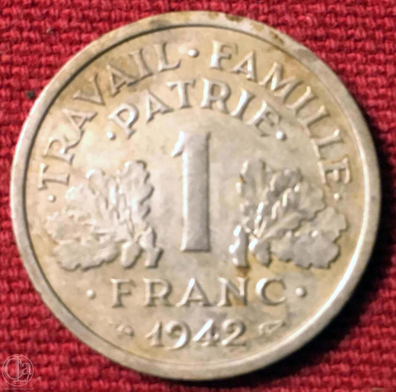
By November 2016, the rotting timber and rusted corrugated iron roof was in a dangerous condition and needed to be replaced. When dismantling the well-head and the top layer of stonework which held it in position, we found a mason's token: a French 1 franc coin dated 1942 bearing the 'Travail Famille Patrie' slogan of the war-time Vichy state. This clearly shows that the roof structure (as shown right) was erected in 1942.
The chain and roller were still in good enough condition to be re-used in a replacement well-head. In 2022 a corrugated iron 'cap' was built by CAL to stop children falling in. At this stage the well resumed used when a submerged pump supplied water for vegetables. - WHERE WAS THE ORIGINAL SERVICE AREA?
- LACK OF ROADWAY
- LACK OF SOOT IN THE CHIMNEY
-


 DOOR STYLES & CONSTRUCTION


Phasing Conclusion
The Pig Sty
The Calf Shed
The Well


By the mid-20th century...


Le Boquet Village
L
e Boquet is a typical rural village in the Bocage Virois in Normandy, France. A village in this sense is a group of perhaps four or five houses which once shared communal facilities such as a well (un puits), a dairy (une laiterie), a bread-oven (un four à pain or boulangerie), a cider press (un pressoir) and an open-air washing-place (un lavoir), etc. At Le Boquet four houses remain and only the pressoir, destroyed in the 1999 gale, has not survived.

Le Boquet has certainly been inhabited from at least the late 15th century or early 16th century, judging by masonry in its earliest surviving building. In October 2016 Robert Waterhouse provisionally identified stonework in the Boquet Old Hall as consistent with at least five phases on construction: 15th century, 16th century, earlier 17th century, later 17th century and 18th century. The clay/cob northern extension (stable and pig sty) is clearly 19th century.
However, the Old Hall bears evidence in the surviving masonry of a previous timber-framed building which would have been entirely typical of the sort of structures that existed throughout Normandy from the time of the arrival of Francs and Saxons and Norman-Vikings through to the 16th century period we call the 'great re-construction' when, in this part of Normandy, timber-built houses were almost entirely replaced by more durable stone-built structures. This period of 're-construction' was undoubtedly precipitated by the appalling destruction caused during the 100 Years' War (14th century and 15th century) and again during the Wars of Religion (16th century).


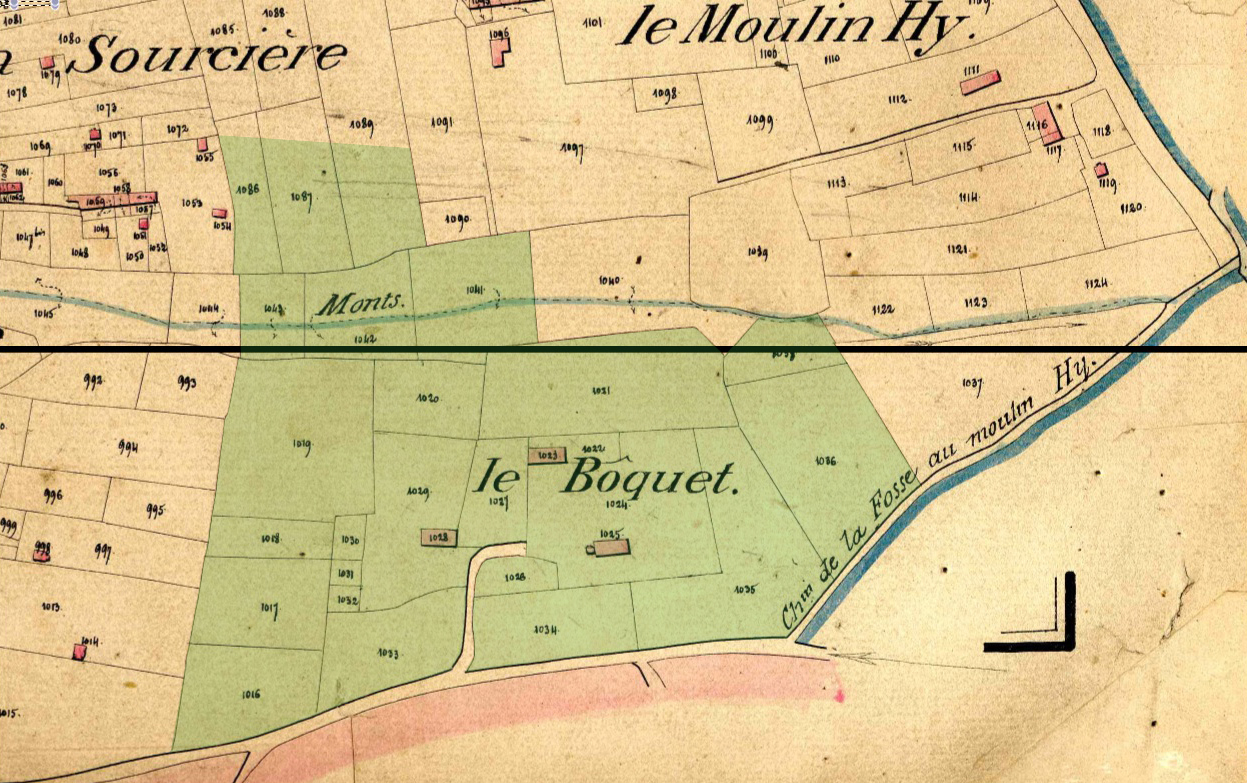
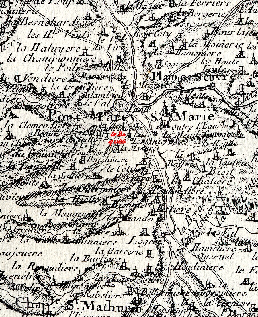
Robert Waterhouse's first sketches as we attempted to 'read' the phasing of the Boquet Old Hall from masonry styles. Le Boquet first appears on a map in the 18th century/19th Carte de Cassini, as Le Bosquet and marked as a hamlet. Dating and phasing the Boquet Old Hall and the separate Boquet House depend upon a knowledge of the developments and characteristics of local 'vernacular' architecture, scientific study of datable remains such as beams, trusses and joists as well as familiarity with the requirements of the local population as rural life evolved and adapted over a period of five centuries or more. For example, some doors in the Boquet Old Hall and in the Boquet House appear to date from the 17th century and 18th century. A number other buildings in the group are clearly 19th century and date from the agricultural revolution of about 1860 when the arrival of canals and railways allowed dairy farming to replace much arable farming, sheep breeding and cider production.

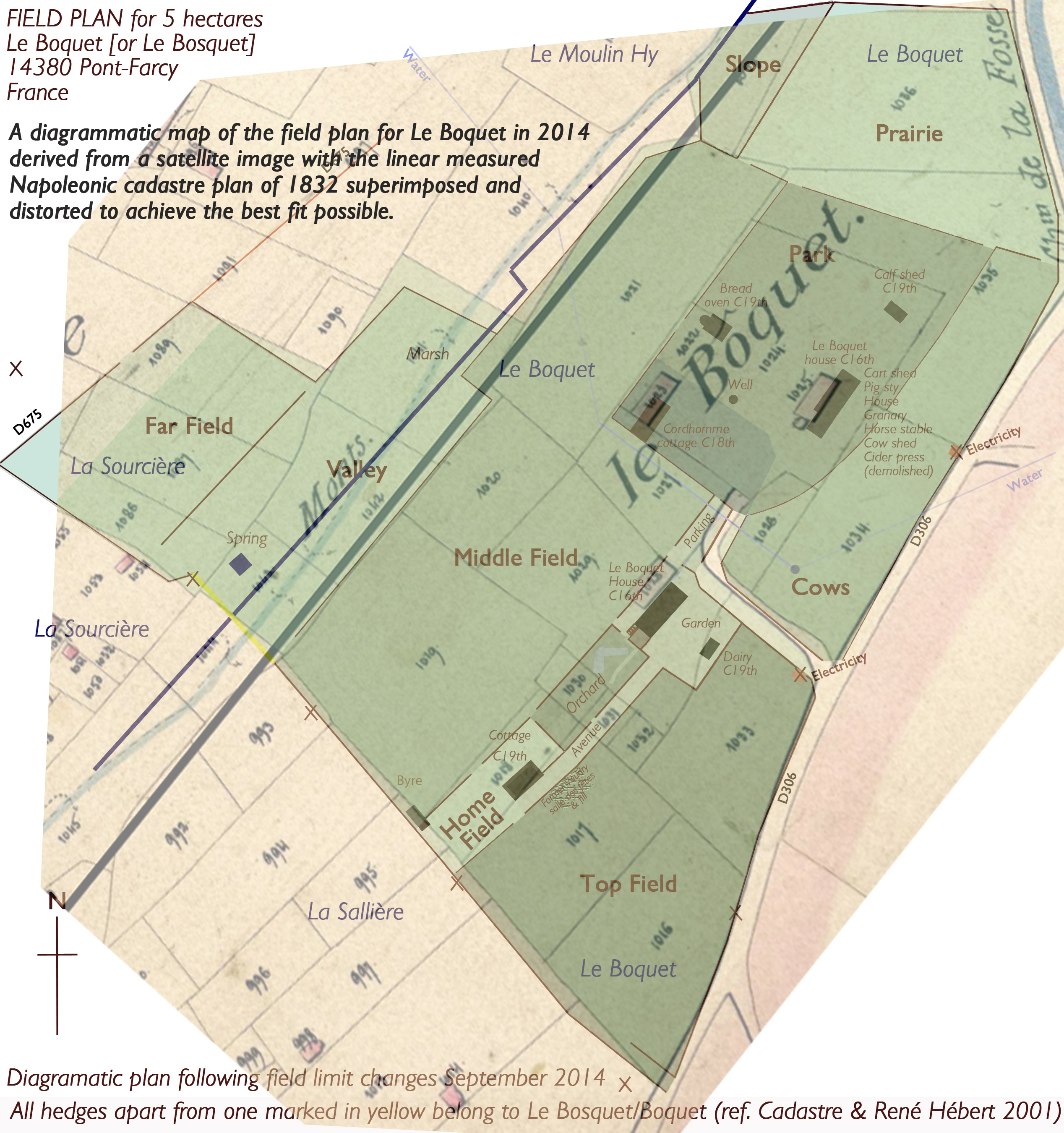
It is hard to say where the limits of Le Boquet's land were from the 16th century to the 18th century. New roads and the effects of the commune system introduced after the 1789 French Revolution have altered the administrative landscape. The dark green area in the image above indicates the two parts – Le Boquet and Le Bosquet – as they are today, Le Boquet lying in Pont-Farcy and Le Bosquet in Ste-Marie-Outre-L'Eau, divided by the D306.
Le Boquet might at one stage have consisted of about 10-15 hectares (25-38 acres), lying on either side of today's D306 road. Until any original documents are found one can only work from what the surviving toponyms or lieux-dit) suggest.
The simplicity of the surviving buildings does not suggest a large estate. However, Le Boquet is one of only a handful of specific places in the area mentioned by Cassini – its nearest neighbours being Beauregard, La Clémendière, La Torignière, La Sallière and Le Moulin Hy. It's soil is many metres deep and very rich – comparable loess.
It is unclear where the boundary lay with La Fosse de Bas to the south, whose present farmhouse was certainly built much later. It is also possible that it originally included an area of land to the north-east, near La Noette, lying between the steep 'new' section of the D306 road and the 'old' road (a now disused sunken lane or chemin creux). The reasoning behind this is that before then there would have been no natural boundary prior the construction of the 'new' road.
 However this study concerns only the western half of the original area, marked in dark green in the large plan above, which includes nearly all the buildings and which now belongs to the author and his wife.
[Note 1. Most of the D306 road is probably ancient though the steep hill section running within an embankment from the Moulin Hy to Le Boquet was probably built in the late 18th century or early 19th century. Before then the road presumably followed the old, surviving but now abandoned chemin creux which still represents the boundary between the communes of Pont-Farcy and Ste-Marie-Outre-L'Eau. Communes were established after the 1789 French Revolution to replace parish administration though they sometimes re-defined boundaries. It should be noted that much of the D306 has steep embankments on each side and was probably lowered to make it easier to use. Since at least the early 19th century the major part of Le Boquet has fallen within the commune of Pont-Farcy, while the smaller part lay within St Marie-Outre-L'Eau. But for the purposes of the official cadastre the two adjacent villages each continue officially to be called Le Boquet and Le Bosquet respectively. It seems safe to assume that Le Bosquet/Boquet in the 16th century and 17th century would have comprised the land on both sides of the D306 which itself probably incorporates parts of more ancient local lanes.]
[Note 2: In addition to the D306, a lane once passed through the middle of the village of Le Boquet – parts of which are still visible today. This lane appears to have begun at a cross-roads to the north-east of Le Boquet's Old Hall and then ran past its north-west main door, continuing past the (south-east) front door of Le Boquet House and running south-west through La Sallière. It may even once have extended as far as Le Ménage. It certainly passed the front doors of at least five other houses built in a straight line (in La Sallièe) and had branches leading off across the valley to La Sourcière (a chemin creux which still existed in 2010) and to La Bénouvière (visible in 2010 but no longer accessible). One part of the main lane can still be seen in the plan below, marked as the 'Avenue' and 'Home Field'. Another part in La Sallière is still in use as a road. This lane may have formed part of an ancient by-way from Pont-Farcy to St Vigor-des-Monts. From Pont-Farcy it would have crossed the Gouvette stream east of Le Moulin Hy and climbed to Le Boquet through a chemin creux (this section being still visible but blocked by municipal rubbish). At Le Boquet it would have offered routes eastwards and southwards to La Noette, La Thorinière and La Fosse. From Le Boquet it led on to La Sallière and Le Ménage before heading off, as it does today in the form of a road, to Les Monts, where it crossed a stream and then climbed up to La Recouvière. An alternative road on the western side of the valley followed the ancient Gallo-Roman road, still known as La Pavée, running from Le Moulin Hy via Beauregard to Ste Marie-des-Monts and then on to Villedieu-les-Poêles. Much of this second route was still accessible in 2010 – though most of La Pavée in the commune of Pont-Farcy has been neglected or lost while, once again, a length of it has been blocked by municipal rubbish.]


Today the village of Le Boquet remains remarkably intact. The stone Well, set in what was once an apple orchard, stands at the centre of a group of four houses. It is not known whether the visible stonework above ground is original. Occupying Germans seem to have had a hand in rebuilding the upper courses of the stonework during the 1940s because in 2017 the author found a German coin and a French wartime Third Republic coin deliberately laid in the coursing in traditional memento fashion. [German troops billeted at Le Boquet operated an anti-aircraft battery on the western side of the Boquet House, overlooking the valley which Allied aircraft used when attempting to destroy Pont-Farcy's road bridge at low altitude.] The well's access point faces away from what is presumed to be the earliest building (the Old Hall) and towards what is thought to be a relatively more recent (perhaps 18th century and currently abandoned) house.
A Bread Oven is still in situ nearby. It would have been built after the French Revolution allowed peasants to bake bread in their own ovens. Its structure (clay walls sitting on a low wall of stone is typical of the mid-19th century.
Sadly, following severe storm damage in 1999, all that remained of a former pressoir on the southern end of the Old Hall were its foundations which now lie beneath the New Hall built in 2017-2021.
The lavoir, probably shared with the owners on the opposite bank is still visible in a bend in the stream in the valley below.
Elsewhere — though not part of the 'communal' property – are other buildings built of solid clay on stone footings: a small Calf Shed with fittings still in place for attaching four calves which were reared in the dark to be sold as veal.
A similar sized building sitting opposite the Boquet House was designed as a Dairy while to the south-west, a very modest single-room Cottage was inhabited by an elderly woman until the 1950s. She had a simple fireplace and one small window facing west... in addition to a 300 metre walk to the well and back whenever she needed water, carrying it in buckets...
Other such buildings may have disappeared. For example, an almost lost clay-on-stone Workshop atelier attached to the Le Boquet House was being restored in 2010 (though in a straw-bale and timber-frame construction) while in the early 21st century there was still clear evidence of the footings of a small building on the north-west side of the Avenue (see map above). At the time of writing the foundations of this little building lie beneath a large wild cherry tree between the Cottage and Le Boquet house.
The Bocage Virois was far from being a prosperous region until the end of the 20th century. Granite was used for the coins, doorways, windows and chimneys of most surviving farmhouses from the late Middle Ages until the 19th century, but nowhere was expensive granite used at Le Boquet until some 20th century improvements were made to the House.
Indeed, even though the land itself is extremely rich, the preservation of Le Boquet as an unimproved 19th century farm (even after the introduction of tractors in 1959) may be due to its relative poverty on the slopes of a small valley where much of the land was not plough-able. For this reason too Le Boquet retained many of the most characteristic features of the Bocage landscape, including its flora and fauna. Sadly many magnificent trees, which had survived the 1999 storm, were cut down by René Hébert before he sold the property in 2000/2001.
All the indications are that this modest village had always been at the lower end of the scale as a subsistence farm. It is not known whether Le Boquet (originally perhaps 10-15 hectares) was ever farmed as a single unit although this seems likely given the volume of the Hall which later served as an agricultural building.
Major changes and re-structuring are likely to have occurred following the French Revolution of 1789 and it may be that the property was divided into separately owned parcels at about this time.
[Note 3: Certainly by the mid-20th century it consisted of four separately owned units. To the west of the D306 two areas were farmed separately by the Hébert and Cordhomme families. The eastern side of the D306 was farmed by the Dedieu family and, from the 1960s, by Marcel Scelles). Three fields (about two hectares) at the north-eastern point and along the western bank of the stream) belonged to the neighbouring Gesnouin family (in the village of Le Moulin Hy) separated from the rest of their farm by the 'new' Villedieu-les-Poëlles road which sliced through their land. The remains of a separatelavoir at an artificial bend in the stream within the Gesnouin land suggests that it had been separately owned for some time. Additionally a very small area, beside the main road and surrounded by the Gesnouin land, had been acquired at some stage by a small house across the road. On the other hand, two parcels of land lying in the neighbouring village of La Sourcière (west of Le Boquet), including the valley bottom and its stream, were incorporated into the Le Boquet farm during the 20th century.]
Significantly, a small rectangular piece of land lying astride the same stream had 'always' belonged to Le Boquet. The explanation for this is clearly that the natural spring there served as Le Boquet's communal lavoir. Owing to the steep drop to the valley, this would have been the only spot in the vicinity where there was relatively easy access from Le Boquet for anyone carrying a quantity of washing. In 2010 vertical slabs of stone which once formed the edge of the lavoir basin were still clearly visible.
Two of Le Boquet's buildings are of particular interest: the Hall (which in this report will be described as Old Hall) and the nearby principal Boquet House.
Le Boquet House

La Maison... the only living room...
-
 In its earliest form the Le Boquet was once an even simpler building than it is today (see impression above). In the picture above, the left-hand side of the building contained just one room: la maison. The right-hand half was entirely agricultural: une grange et une étable.. The earliest masonry dates from the mid-late 16th century although significant modifications were made in the mid-19th century when Normandy's dairy revolution transformed rural life. It is an entirely typical example of 16th century farm house architecture in the Bocage Virois – conforming to the 'maison-grange-étable' formula.
-
Originally the whole building was thatched and the main southern part of the house consisted of a single 'hall' room (la maison), open to the roof, with a large open hearth and beaten-earth floor. It had at least one door and window on the eastern side. The northern, agricultural half of the building had a lower roof-line, consisting of a raised granary with a raised doorway and a stable with two entrances and a hayloft above. There is evidence in the external stonework that the hall room once had a low doorway on the western side (where today there is a window).
-
 The original fireplace was destroyed in the 1990s and replaced with the brick structure we see today but it once had an imposing timber mantle supported on timber corbels. In 2001 René Hébert told us the fireplace he destroyed was almost identical to the one that survives at Le Boquet's Hall nearby – see photo.
 The end of one of those original corbels that can be seen projecting through the wall into today's kitchen.
-
The oldest masonry in the building is the entire length of the western wall and the entire length of the southern chimney gable wall (excluding today's fireplace). The recessed cupboard (whose door and shelf have sadly not survived), dates from the same 16th century period.
- The hall room was where people lived, ate and slept. Boys and perhaps a female servant are said to have slept in the hayloft while girls had a mattress under the table. Their parents would have slept in a corner bed. The usual furniture consisted of little more than a large wardrobe and a long table in front of the fire with a bench on each side. Cooking was done in the fireplace and beneath the recessed cupboard there was clear evidence in 2001 that there had been a kitchen sink there. We hoped to find an exit hole through the thickness of the wall for a sink like this, but it may be this was lost when most of the eastern facade was rebuilt, perhaps in the late 18th century or early 19th century.
We remember seeing several houses that were still inhabited exactly like this in the first years of the 21st century (Raymond Manson, Alfred Lecanu, etc). Apart from electric lighting, a gas hob, a television and a fridge, not much separated their domestic arrangements from those of the 16th century or 19th century. Even water was still sometimes pumped from a well and several people were still using earth closets in a small timber hut a short walk from the house. The granite sinks were surprisingly large and extremely shallow with a long tapering spout that passed right through the wall. Occasionally versions of these exited into a pigsty. A metallic or ceramic container with a small tap often hung above the sink containing a litre of two of water.
-


 To get an impression of what the main 'hall' room looked like before today's ceiling was introduced, it's worth looking at what is now the bedroom above. There you will see the long curved masonry of the chimney flue as well as a massive truss beam both of which would have been very visible from the hall room below.
-
On the underside of the truss beam can be seen an 'escutcheon' that in a grander house might have been decorated with a carved or painted coat of arms. Something is indeed marked on it but no one has yet deciphered the vague marks! This escutcheon would only have been visible, of course, when the hall room below was open to the roof (or at least to the height of the wall-plates).
-
 The first ceiling was probably introduced in the late 16th century or early 17th century when at least one large transverse beam and its oak joists (all now gone) would have separated the ground-floor room from a new hayloft (today's bedroom above). Almost certainly the floor of the hayloft would have consisted of 30cm long split chestnut 'kindling', wrapped in straw and mud and laid side-by-side across the joists, onto which a 15cm thick bed of clay laid. The height of this ceiling can be seen in the line of blocked-up joist holes above the cupboard recess in the southern wall. This first ceiling and its beam had vanished by 2000, replaced in the 1980s by the ceiling we see today.
 - Access to the hayloft was via an external upper doorway which we have preserved as a window in the bedroom. But in 2002 we sadly had to cover the beaten-earth floor in the hall with a level and more practical tiled floor.
-

 The western window with its brick facings must have been created after 1860 and perhaps in the early 20th century. There is a mystery here though because it appears that there had previously been a low doorway with clearly defined masonry reaching down to ground level. Was there once a primary or secondary door here and, if so, why is it so low?
 -

 The position of the eastern window is probably close to that of a 16th century window but the original would have been much smaller. It seems likely that the entire eastern facade with front door and window were rebuilt in perhaps the late 18th century or early 19th century. The eastern window retains its timber 'cheeks', used to bar a security shutter in place, and the front doorway contains just one of its two 'cheeks', the northern one having been lost when the facade around the granary door was re-worked. The heavy front door itself is 19th century.

 Both the east and west windows sit on narrow walls which left space beneath them for log-boxes that contained firewood. The cupboard behind the front door in the north-east corner of the room is all that now remains of the full-height but narrow communicating doorway between the maison and the grange.
-
 As part of its original construction, the house seems to have had an extension on the southern chimney gable wall. A horizontal drip-course larmière survives on the 'outside' of this wall (now enclosed by, but visible within, the raised studio). This might have been related to cider-making and/or a cave containing cider barrels and it could well have falled victim to the prevailing wind and rain in the same way as its equivalent at Le Boquet Hall (see above). In any event, this was replaced by a building which survives today. In 2001 it was an unlit, low-ceilinged cave constructed in the typical 19th century fashion: one-metre high stone footings with solid cob walls on top. The outline line of its pointed gable roof can be seen from within today's studio where it clearly cuts across the drip-course of the earlier building. In 2010 the roof of this extension was raised and a new gable frame installed (off-vertical by Gilles Debreuil) to create a kitchen and shower-room below and a studio room with an exterior stairway above.
-
 Whatever, it seems to have been replaced by the cave we inherited, which is a typical example of 19th century rural construction: clay-cob walls on stone wall footings about one metre high. This contained cider barrels under a very low ceiling until 2000 and was converted by us into a kitchen and shower-room about six years later. We were able to create a studio with an external stairway above.
-
La Grange et l'Étable... a working area...
The northern half of the house consisted of a granary la grange – a raised threshing-floor with a hayloft above it – and beyond that a stable l'étable either for sheep or three or four or cows.
The grange had its own raised external door (where now there is a French window) while there was also a direct communicating doorway between the hall and the granary where there is now a cupboard containing electricity meters.
Until the 19th century, grain was the principal farm product in this area and, in July or August, teams of men armed with flails, beat the freshly cut wheat, barley, etc., to separate the grain from the straw. With the arrival of the dairy industry in nearly every local farm from about 1860 onwards, the grange served both as a granary in summer and as a manger for cows in winter. The cows passed their heads through bays in the partition, feeding off hay tossed down onto the granary floor from the hayloft above. This floor, invariably surfaced with beaten earth, would have been at or above the level of the adjacent main living-room (maison) while the floor of the cow shed would have been about 50 cms below this. The grange was also a place for storing grain, seed, flour and valuable hand tools and equipment. The raised granary and the partition with its bays were removed by René Hébert in the 1990s when he also created the doorway that today links the hall (dining room) with the granary and stable (drawing room). - A ventilation hole in the old (lower) masonry of the north wall, (about one metre above the ground and since roughly blocked in by René Hébert) once gave chickens access to the cow shed inside.
-
 A ventilation hole in the west wall near the entrance into the cow shed has been been blocked but its outline remains visible.
 - The interior of the north wall of the cow shed, rendered prior to 2001 by René Hébert, was badly eroded by cows which had rubbed their bottoms against it for many generations.
- Within the cow shed, near the centre of the north wall and about a metre above ground level, was a typical lantern 'niche'. It was adapted in about 2004 to pass a chimney pipe from a Godin stove through the wall to a vertical stainless steel chimney outside.
-
 The cow shed originally had two entrances for allowing cows in and out as well as for removing manure and slurry. At Le Bosquet a low doorway at the northern end of the east facade is still visible although it was blocked up a long time ago. Inset 'cheek' timbers remain visible on either side of the doorway to allow for 'barring' of the doorway. According to René Hébert in 2001, an identical doorway existed on the opposite (western) wall which he enlarged to form a French window.
 - Prior to 2001 René Hébert created a single living room from the former grange and étable, at the low level of the former cowshed, but water-proofed it and entirely lined it with white tiles. In 2011, C & S Long raised the level of the floor of this room by about 25 cms with timber joists and a timber floor.
-
 On the south wall of what is today's drawing room (the northern half of which was once a cow shed) can still be seen two of the timber corbels that once supported the ceiling of the raised granary (grange) and which supported a hayloft above. Directly above these, on today's upper floor, can be seen the stubs of two original roof-truss frames which were cut out when the roof at this end of the house was raised to match the height of the southern part of the building.
 Back in the drawing room, on its east wall (and at the same level as the two corbels on the south wall) can be seen the bottom of the original external doorway into the hayloft. This recess survived the rebuilding of the exterior masonry on the eastern facade of the former grange and étable. This rebuilding occurred when the single story building was raised to create living space above. In the last decade of the 20th century. René Hébert himself replaced a cob (argile) upper wall on the north and west sides with badly laid stone that he had transported from the post-WWll salle des fête from Vaudry. Apparently he did this to replace clay walls that had collapsed. Fortunately he seems to have employed a good mason to rebuild and raise the eastern facade, introducing three windows.


- Above the main living-room of the farm house was a hayloft that
Le Boquet Analysis Images 2026
- Le Boquet Analysis Slide Show (2026)
- Le Boquet Fief à Pont-Farcy par Dominique Doublet (2020)
- Pont-Farcy – Some notes on its history
- The Search For Sidney Bates, VC A story of outstanding courage in the Battle of Normandy (2003)
- Tales from The Magic Wardrobe Explaining history through strip cartoons (2007)
- Mont Saint Michel in Normandy and St Michael's Mount in Cornwall Linking two St Michael's Mounts (2007)
- Tonsures, Tin, Bronze and Bells A study of Norman links to the Cornish tin trade (2009)
- St Michel, l'Étain et l'Âge des Cloches Talk given at the Archives Départementales, St Lô (2009)